Hvordan borhullinspeksjonskameraer fungerer: teknologi og kjernekomponenter
Hva er et borhullinspeksjonskamera?
Borhullsinspeksjonskameraer er i utgangspunktet verktøy som tar detaljerte bilder inne i trange rom under bakken der mennesker ikke lett kan komme. Utstyret har ganske god bildebehandlings-teknologi som viser hva som skjer med stein, hvor faste strukturene er, og om det er vann eller andre væsker til stede. Disse fungerer i hull med en diameter fra omtrent en halv tomme opp til over tre fot. Vanlige inspeksjoner utført på bakkenivå er rett og slett ikke godt nok når vi trenger å vite nøyaktig hva som foregår under overflaten. Derfor er disse kameraene så viktige for å kartlegge jordstabilitet og overvåke underjordiske strukturer.
Utvikling fra analog til digital panorameringsavbildning
Tidlig avbildning av borhull baserte seg på analog filmkamera-teknologi med begrenset dekning og manuell fototolkning. Moderne systemer bruker digital stereoparteknologi som fanger inn 360° panoramabilder av borhullvegger med oppløsning under 2 mm, noe som muliggjør tredimensjonal karakterisering av bergmasse (2024 Borhullsavbildningsrapport). Denne endringen gjør det mulig:
- 250 % raskere datainnsamling sammenlignet med eldre systemer
- Automatisk bildestikking som erstatter manuelle mosaiske bilder
- Sanntids-zoom for å undersøke mikrofrakturer
Nøkkeldeler og driftsprinsipper
Tre essensielle komponenter definerer moderne borhullskamera-systemer:
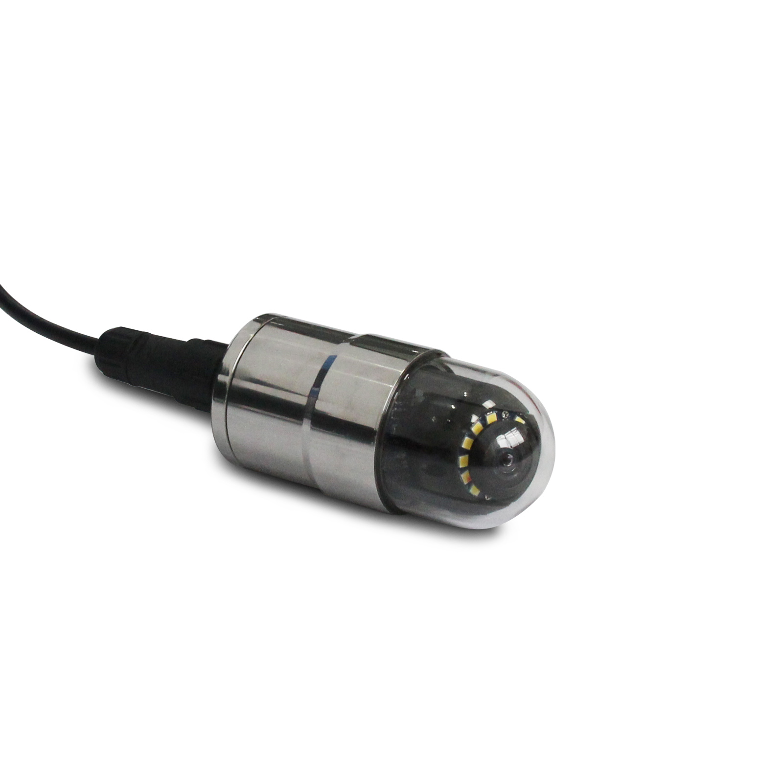
- Bildehode : Kombinerer LED-belysning (¥5 000 lux) med en 4K-optisk sensor, ofte montert på en motorisert panorering-/kippemekanisme
- Innsettingssystem : Fleksible skyvestenger med dybdemerkede kabler, rangert for trykk opp til 30 MPa
- Behandlesenheter : Robust felt-dator som kjører AI-assistert analyseprogramvare
Riktig systemkalibrering sikrer 1 % radial forvrengning over temperaturer fra -20 °C til 60 °C. Integrasjonen av MEMS-gyroskoper og akselerometre gir romlig orientasjonsnøyaktighet innenfor 0,5°, noe som muliggjør nøyaktig måling av sprekkeorienteringer og åpningsbredder – avgjørende for pålitelig geoteknisk vurdering.
Teknologiske fremskritt som forbedrer nøyaktigheten i hullbildevisning
Moderne inspeksjonskameraer for borehull oppnår nå millimeter-skala oppløsning gjennom innovasjoner innen optisk avbildning, akustisk telemetri og AI-drevet analyse. Disse fremskrittene løser begrensninger som forvrengte panoramabilder eller utsett tolking, og gjør at ingeniører kan oppdage under-millimetersprekker og dynamiske endringer med ubetinget pålitelighet.
Høyoppløselig optisk versus akustisk og elektrisk avbildningsteknikk
Optisk avbildningsteknologi kan kartlegge hele brønnsveggene med en oppløsning på under 1 mm per piksel takket være de avanserte stereokameraene og LED-belysningsoppsettene. Disse overgår akustiske metoder som typisk har en oppløsning på rundt 2–5 mm og som rett og slett ikke fungerer godt når det er mange revner i steinen. Elektrisk avbildning fanger flytvier veldig bra, men gir egentlig lite i form av reelle visuelle detaljer. Ifølge en nylig studie fra 2024 om geoteknisk avbildning, oppdaget optiske systemer omtrent 87 % av de små revnene under 2 mm i granittprøver, mens akustiske systemer bare klarte 64 %. Og felttester har også vist noe interessant: når selskaper kombinerer optiske og elektriske sensorer i hybrid-systemer, reduseres feiltolkninger med omtrent 41 %, ifølge Ponemons forskning fra i fjor.
AI-drevet analyse for automatisert deteksjon av revner og defekter
Maskinlæringsystemene kan håndtere rundt 10 tusen borehullsbilder hver time nå, med omtrent 94 prosent nøyaktighet når de oppdager sprekker. Det er en betydelig forbedring sammenlignet med de gamle manuelle metodene som bare nådde rundt 72 prosent. Disse konvolusjonelle nevrale nettverksoppsettene er ganske gode til å skille mellom ulike typer sprekker også. De klarer å skille mellom trekk- og skjærsprekker med omtrent 89 prosents pålitelighet, bare ved å se på hvordan overflater ser ut og hvor brede sprekken faktisk er. En nylig test tilbake i 2023 viste noe svært interessant. AI-en fant 62 prosent færre feil som mennesker hadde oversett i skifer-gasbrønner. Det beste er at det som tidligere tok nesten to hele dager med arbeid, nå gjøres på bare tjue minutter for hver hundre meter borehull analysert.
Sanntidsdataoverføring og skybasert behandling
4G/5G-aktiverte kameraer strømmer nå 8K-video fra dyp opp til 1 500 meter med mindre enn 300 ms forsinkelse, noe som eliminerer behovet for manuell innhenting. Skyplattformer støtter samarbeid mellom flere team gjennom integrerte verktøy:
| Funksjon | Tidsbesparelser | Nøyaktighetspåvirkning |
|---|---|---|
| Verktøy for sanntidsannotering | 55 % raskere | ±2 % avvik |
| Automatisk generering av PDF/3D-modeller | 68 % reduksjon | N/A |
Ingeniører som bruker sanntidssystemer, rapporterer 31 % raskere prosjektfullførelse i grunnvannsmonitoreringsprosjekter (GeoAnalysis 2024).
Kritiske anvendelser innen geoteknisk, gruve- og energisektor
Deteksjon av sprekker og ledd i bergmasser ved hjelp av optisk avbildning
Optiske avbildningssystemer med høy oppløsning kan kartlegge sprekkenettverk med nøyaktighet ned til nesten millimeter, og gir ingeniører komplette 360-graders bilder av hva som skjer inne i brønnevergene. Med disse bildene får fagpersoner mye bedre innsikt i hvordan ledd er orientert og plassert i forhold til hverandre, noe som er svært viktig når man vurderer om skråninger vil holde seg stabile i operasjoner som gruvedrift i dagslys eller bygging av underjordiske tunneler. Nyere forskning fra i fjor innen geomekanikk viste faktisk noe ganske betydelig om denne teknologien. Studien indikerte at bruk av optisk avbildning reduserer feil ved tolkning av sprekker med omtrent to tredjedeler sammenlignet med eldre metoder som involverer fysiske kjerneprøver tatt fra bergformasjoner.
Overvåking av brønntetthet i grunnvanns- og oljebrønner
I energidrift viser kameraer belægningkorrosjon, sementavbinding og sandinntrenging i sanntid, noe som støtter proaktiv vedlikehold for å forhindre feil. For grunnvannsmonitoreringsbrønner identifiserer de vekst av biofilm og sedimentering som påvirker vannkvaliteten, og sikrer nøyaktig innsamling av data over tid.
Vurdering av strukturell stabilitet i mineshafter
Periodisk borehullsbildetagning evaluerer tilstanden til shafthutfôring og oppdager spenningsindusert deformasjon. Avanserte systemer utstyrt med termiske bildemoduler kartlegger temperaturanomalier knyttet til økende bakketrykk – en innovasjon fremhevet i nyere forskning på geotermisk boring.
Case-studie: Identifisering av underjordisk deformasjon i skredsoner
Under en vurdering av skredfare i Himalaya i 2022, satte ingeniører inn et borhullskamera på 120 meters dyp for å analysere skjærsoner. Bildestøting avdekket gradvis sprekking i leirrike lag, noe som muliggjorde målrettet dreneringsinstallasjon som reduserte skråningsbevegelse med 89 % innen seks måneder.
Sikring av datakvalitet: Kalibrering, forvrengningskontroll og kvantitativ analyse
Nøyaktig avbildning i borhull er avhengig av systematisk kalibrering, korreksjon av forvrengning og standardiserte måleprotokoller. Disse metodene sikrer troverdige data for tekniske og miljømessige beslutninger.
Kalibreringsteknikker for pålitelig avbildning i borhull
Regelmessig kalibrering justerer sensorer ved hjelp av rutemønstre for å bekrefte pikseloppløsning og fargefidelitet. Ifølge presisjonsmålingsstudier kan avvik så små som 0,1 mm i sprekkebredde korrigeres på denne måten. Moderne systemer har også automatiserte prosedyrer som kompenserer for temperaturindusert sensordrift under utplassering.
Minimalisering av bildefortekning i panoramakameraer
Panoramalinser fører til tønnfortekning, som forvrider geometriske målinger. Sanntidsprogramvarealgoritmer korrigerer radielle forvrengningsmønstre, mens optimal belysning og antirefleksbelgninger minimerer refleks fra grumsete vann. Felttester viser at disse teknikkene forbedrer nøyaktigheten i gjenkjennelse av detaljer med 35 % sammenlignet med ukorrigert avbildning (Ponemon 2023).
Måling av sprekkeåpning, orientering og andre parametere
Etterbehandlingsprogramvare konverterer kalibrerte bilder til kvantitative datasett via 3D-koordinatavbildning. Kantdeteksjonsalgoritmer beregner nøkkelmål som sprekkeåpning (0,05–20 mm rekkevidde) og helningsvinkel (±1° oppløsning). Nye fremskritt gjør det mulig å automatisk måle leddavstand i samsvar med bransjestandarder, noe som sikrer konsistens innen bergverk, geotermisk energi og sivilingeniørarbeid.
Beste praksis for feltbruk av inspeksjonskameraer for borehull
Riktige nedlukkingsteknikker og håndtering av utstyr
Å holde senkehastigheten mellom 0,1 og 0,3 meter per sekund hjelper til med å unngå frustrerende kabbelapper og uønskede kollisjoner med veggen under operasjoner. For systemer som er designet for å fungere i dyp over 150 meter, må operatører ha to separate sikkerhetskontroller på plass, typisk involverende både et taljesystem for å holde alt riktig justert og en belastningscelle som holder øye med hvor mye spenning som faktisk er til stede. Ifølge ny data fra en geoteknisk studie publisert i fjor, kan nesten 4 av 10 mislykkede innsatsoperasjoner spores tilbake til feil ved håndtering. Derfor insisterer de fleste fagpersoner på grundige inspeksjoner før noe senkes ned i brønnen – sjekke kabler for slitasje og sørge for at de små stabiliseringsfinene på kameraet er hele og fungerer korrekt.
Håndtering av miljøfaktorer: vannklarhet, trykk og temperatur
Når vannet blir svært grumset, synligheten avtar dramatisk, noen ganger inntil 70 %. Det betyr at dykkere ofte må skyll ut utstyr på forhånd eller bruke kjemiske behandlinger for å gjøre det klart. Utstyret selv må også tåle disse forholdene. Trykkkompenserte kabiner fungerer problemfritt ned til over 150 meter, noe som er imponerende når man ser på hva som skjer under vann. Termiske buffer er en annen viktig egenskap – de forhindrer at linser slører ved store temperaturforandringer, som noen ganger kan overstige 30 grader celsius mellom dykk. Felles tester har vist at kombinasjonen av adaptive LED-lykter med en lysstyrke på rundt 10 000 til 15 000 lux sammen med spesielle anti-refleksbelegg gir stor forskjell for å se tydelig i vanskelige siktforhold.
Integrering av borhullinspeksjonskamera med andre nedhullsensorer
Når kameraer synkroniseres med gammastrålespektrometre eller resistivitetssensorer, reduseres unødvendige turer tilbake til samme sted. De fleste i feltet bruker i dag standardprotokoller som MODBUS RTU, fordi de hjelper til med å kombinere ulike data tydelig og holde tidsstemplet nærme hverandre – vanligvis innenfor omtrent et halvt sekund. Tilbake i 2021 ble det gjennomført en test der kombinasjon av optisk informasjon fra kameraer med målinger fra temperatur- og pH-sensorer faktisk forbedret arbeidseffektiviteten med omtrent 27 % under vurdering av forurenset grunnvann. Etter at all denne dataen er samlet inn, kontrollerer fagpersoner typisk funnene mot hverandre ved hjelp av 3D punktskyoverlegg. Dette hjelper til med å oppdage vesentlige forskjeller mellom datasett, spesielt varians over 5 % som definitivt må undersøkes nærmere.
Ofte stilte spørsmål
Hva er hovedbruken av brønninspeksjonskameraer?
Borhullsinspeksjonskameraer brukes hovedsakelig til å ta detaljerte bilder av underjordiske strukturer, noe som gjør det mulig å analysere bergestabilitet, vannforekomst og forhold under bakken.
Hvordan overfører borhullskameraer data i sanntid?
De bruker 4G/5G-teknologi til å strømme høyoppløselig video med lav latens, noe som letter sanntidsamarbeid via skybaserte plattformer.
Hvilke fremskritt er gjort innen nøyaktigheten av borhullsavbildning?
Teknologiske fremskritt inkluderer millimeterpresis oppløsning, forbedret optisk avbildning og AI-drevet analyse for økt pålitelighet.
Hvordan hjelper borhullskameraer i gruvedrift?
De kartlegger sprekkenettverk i bergmasser og gir kritisk innsikt for vurdering av skråningsstabilitet og sikre gruvedriftsoperasjoner.
Innholdsfortegnelse
- Hvordan borhullinspeksjonskameraer fungerer: teknologi og kjernekomponenter
- Teknologiske fremskritt som forbedrer nøyaktigheten i hullbildevisning
- Kritiske anvendelser innen geoteknisk, gruve- og energisektor
- Sikring av datakvalitet: Kalibrering, forvrengningskontroll og kvantitativ analyse
- Beste praksis for feltbruk av inspeksjonskameraer for borehull
- Ofte stilte spørsmål